
This blog post was first published on sketchingsummits.com.
November 3-5, 2023 | 32 miles
About our Route
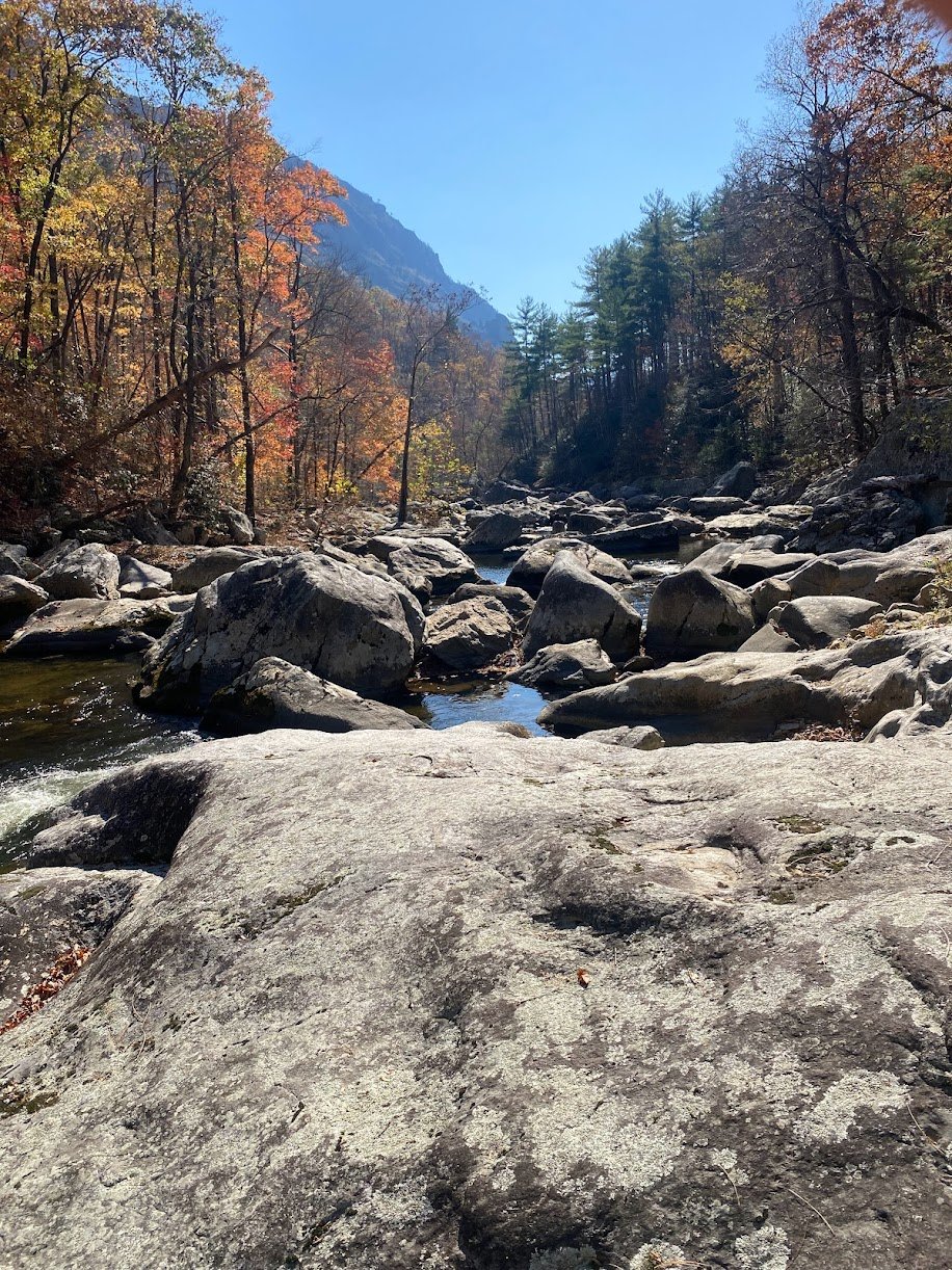
The Linville Gorge, sometimes known as the “Grand Canyon of the East”, is located near Morganton in western North Carolina. It is known for its challenging hikes and spectacular views, with popular day hikes at Table Rock, Hawksbill, and The Chimneys. The majority of the Gorge (and all of our route) lies within the Linville Gorge Wilderness Area of Pisgah National Forest. There are number of different trails within the wilderness area, and hiking the Gorge as a loop is a challenge that should be on every experienced hiker’s bucket list! This loop route, which can be done in a number of different ways depending on water crossings and the hikers’ preference, and can be somewhere in the 25-35 mile range. It has been sarcastically and unofficially named the “Is That All You Got?!” loop, and has a reputation for being some of the hardest hiking North Carolina has to offer.
We started our hike at Pine Gap, starting immediately with a descent down the Linville Gorge Trail. This took us past Brushy Ridge Falls and Babel Tower. At Devil’s Hole we crossed the river, which luckily proved to be very manageable due to the low water and drought-like conditions we are currently experiencing. We hiked up Devils Hole to get to Jonas Ridge, where we camped, making for a 6 mile first day. On our second day we hiked south to Hawksbill (taking the side trail to the summit), then road walked on 210 to Table Rock Gap. Eventually, Table Rock Gap Trail joins the Mountains to Sea Trail (MST). We followed the MST to Table Rock (again taking the side trail to the summit), through the Chimneys, and up and back down Shortoff Mountain. We crossed the Linville River again on the MST, camping on the western side of the Gorge. On Day 3 we followed the MST to Linville Gorge Trail. Here we turned on Linville Gorge Trail (sometimes known as Leadmine trail), leaving the MST behind. We followed this trail through Daffodil Flats, past many beautiful campsites and swimming holes, and eventually turned on Conley Cove trail to climb out of the Gorge. We walked the dirt road, 105, back to our cars at Pine Gap.
You can download a detailed and accurate map for free on Avenza here, and this free app will allow you to navigate without cell service. This map differentiates between official trails and unofficial “social trails”. We stuck to official trails, which I suggest.
You can print this same map at this link for free. I highly suggest having a paper map in addition to phone navigation.
Choosing our Trail
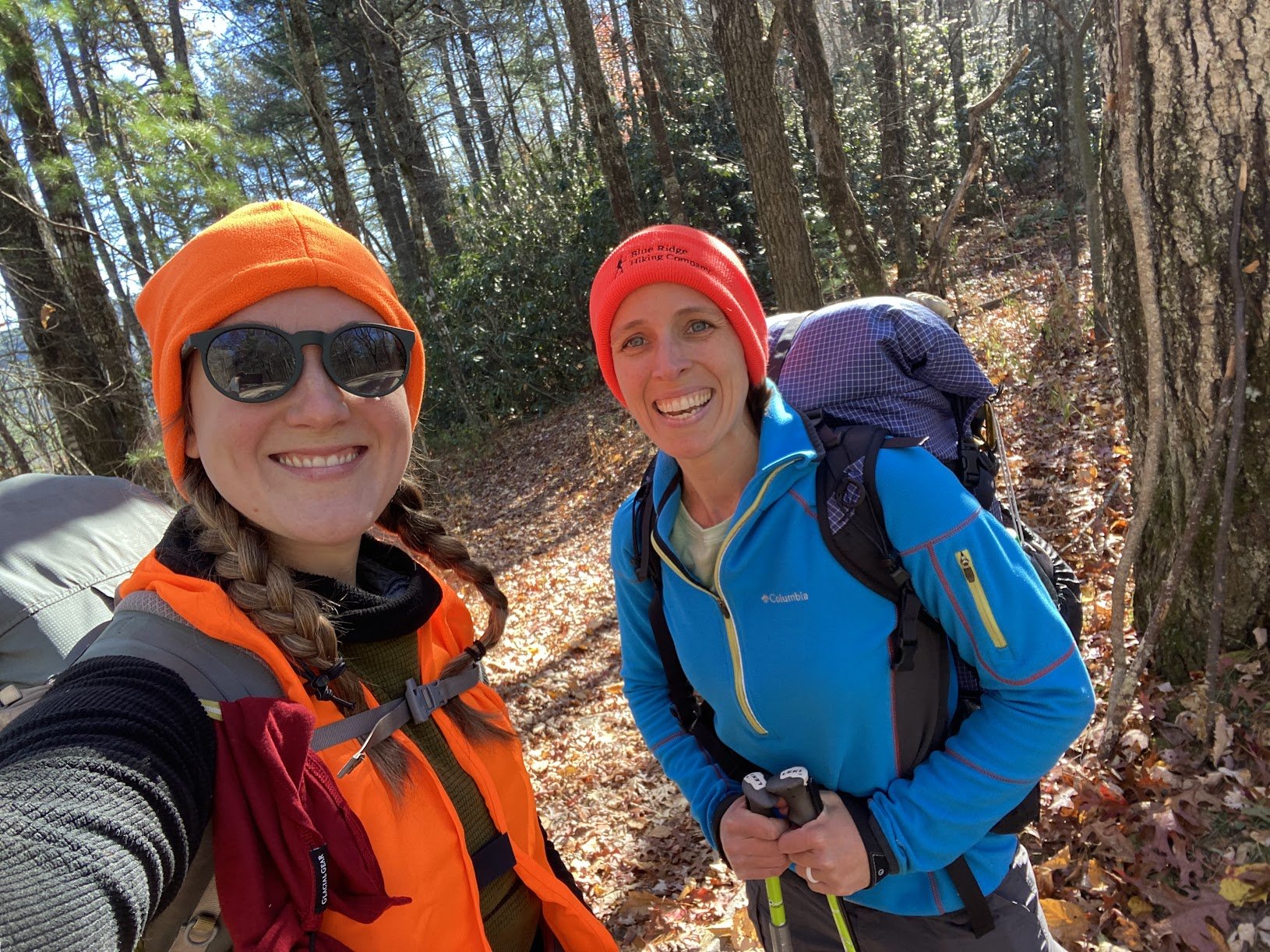
As the guiding season started to come to a close, Hannah (another guide for Blue Ridge Hiking Company) and myself were eager to spend a little time on trail without having the responsibility of guiding a trip. We originally planned to hike the Foothills Trail of South Carolina, but we had some cold temperatures forecasted for this 6 day itinerary. Last minute we opted to switch to a 4 day trip to avoid the two coldest days. I suggested that we scope out the Linville Gorge instead, as we just received news that Blue Ridge Hiking Company had, at long last, acquired permits to guide there! I knew it was possible to make a loop through the Gorge and began doing some research on how. There are three popular places to cross the river, and a network of trails on either side of the gorge, some along the river and some along the ridgelines. Hikers are invited to invent their own route, picking the trails that best suit them and the time of year they are hiking. Regardless of the route taken, the loop is referred to as the “Is That All You Got?!” loop, a sarcastic reference to how challenging it is. River crossings are often the main factor one should consider when choosing a route, having to pick between Brushy Ridge, Devil’s Hole, Spence Ridge, and the MST. Luckily the water was low so we could expect mild river crossings and I boldly opted for crossing at Devils Hole despite having little intel on the current conditions. We decided that if that crossing looked dangerous, we would continue down to Spence Ridge, where I knew other hikers had safely crossed recently. The benefit of crossing at Devil’s Hole was that it would put Hawksbill on our route rather than forcing us to skip it or hike miles out of our way to see it.
I used the Linville Gorge Facebook group to acquire most of my intel on the river crossing and trail conditions. I also paid attention to the Avenza map, which rates the trails as Blue Squares, Black Diamonds, and Double Black Diamonds, following the Ski Slope rating system to determine difficulty.
I originally planned this route to take 4 days and 3 nights. The Linville gorge requires that hikers get a permit for weekends between May and October due to overcrowded. Our November start date meant this wasn’t required. However, I didn’t realize that the 3 day/2 night camping restriction within the Gorge was a year round requirement and not just for the months when a permit was required. When we saw signage clarifying this, we changed itinerary and pushed for bigger miles on the last day to finish without violating this requirement.
 Day 1 (6 miles)
We started by parking at the Linville Falls Visitor center and doing the short hike, without our packs, out to the Falls and surrounding overlooks. The trails in this area are short, well-marked, and easy to hike. They are mildly steep in some parts but well maintained and easy to follow. This is a great spot for day hikers to get a peak into the Gorge and see how the water cuts through the giant boulders and rock faces that line the river. We explore for about an hour, then go back to our cars and drive to Pine Gap Parking on Old 105 to start our loop.
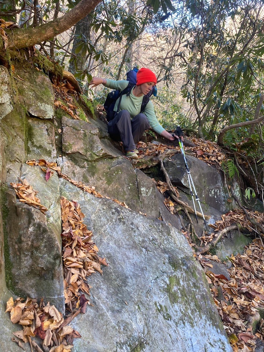
Immediately, our hike down into the Gorge along Linville Gorge Trail is rugged and challenging. The trail is rocky and rooty, and covered in dead leaves that are slippery and make it impossible to tell what you will be stepping on. In a few spots we have to get on our butts to scoot down, or else take off our packs to get past a blow down. The trail is a fun challenge for us, though the slippery leaves do make me nervous.
We arrive at Bynum falls in time for lunch, and I do a quick painting of the cascade. We continue along the trail, passing Brushy Ridge Falls without noticing it or taking note of how the river crossing would be here. Our pace is slow due to the tricky footing of the trail. We arrive at Babel Tower to find a beautiful campsite. I would recommend camping here, but water is actually trickier than it would seem. While the trail does hug the river, you are often on cliffs high above the water with no access to the river. During a wetter season one could get water sources at some of the tributaries but this time of year everything is dry. We drop our packs and climb to the top of Babel Tower, which provides stunning views of the Gorge and Linville River. I hope to come back here at some point to do some on-site painting.
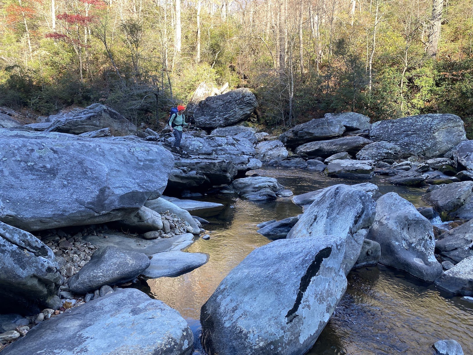
Returning to the Linville Gorge Trail, we hike south looking for the Devil’s Hole Crossing. We pass it without noticing, and turn back after checking our GPS. The side trail to the river is hardly noticeable, but has been marked with some orange tags. We follow the tags to the river, down a steep slope with rhododendron slapping us in the face along the way. I was nervous and excited for this river crossing but it proved simple enough. The water was low and large rocks provided an easy trail across the river. In two spots we probably could have jumped from rock to rock, but with heavy packs on we opted to take our shoes off and step through the river to be safe. On the western side of the river we take a few minutes to fine the Devil’s Hole Trail, but eventually it makes an appearance. We trudge up the steep and overgrown trail, gasping for breath along the way. We must check our GPS multiple times to ensure we are on track. Our heart rates are high and we are covered in sweat by the time we reach the top and intersect with Jonas Ridge Trail. We set up camp here, at a beautiful and flat campsite. We have it to ourselves for most of the evening, but right after we get in our tents we hear sniffing and rustling. We shout at the critter, who doesn’t sound like anything larger than a racoon, but he has no interest in leaving. We are confident he won’t mess with us, but he continues to circle our campsite for hours. I name him Russel. Twice, we get out of our tents to check on the food that we hung, and thankfully it remains undisturbed. We both finally fall asleep, but wake up to the same loud crashing around 4am. We aren’t sure if it is Russel, a larger critter, or just a falling branch, but it takes us a while to fall back asleep.
Day 2 (13 miles)
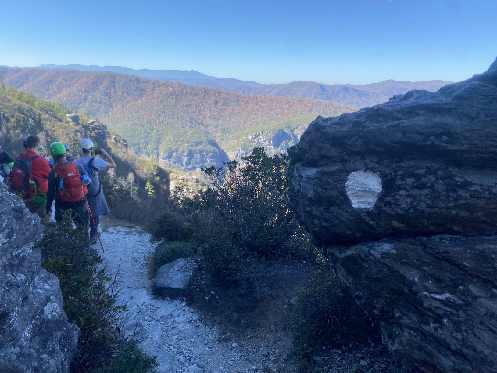
Despite our poor sleep on night one, we wake up eager for the views that we know day 2 will hold. The drought resistant water source on Road 210, near our campsite, gives us a slow but useful trickle and we fill up, knowing water will be scarce for the day. With heavy packs we head up Hawksbill Mountain. The views are spectacular, and we enjoy the summit for a while. At one of the campsites near the top, we see smoke coming from a fire pit. The campsite is abandoned, but there are still embers glowing in the firepit. We are in near-drought conditions and fire risk is high, so we curse the irresponsible hikers that opted to have a fire without ensuring they had enough water to douse it. We are already concerned we won’t have enough drinking water for the day, but we each sacrifice a half liter to put out the embers. On our hike down Hawksbill we ask the day hikers we run into if they would do the same. The trail leads us to Road 210, which we follow for about a mile until we get to Table Rock Gap Trail. It soon joins up with the MST, which we follow to the base of Table Rock. Here there is a .2 mile side trail to the top of Table Rock, though halfway up we are both questioning the accuracy of that measurement. It seems to take forever and we pass several other huffing and puffing hikers along the way. The summit is beautiful and not too crowded for a Saturday, and we enjoy a quick snack. On the hike back down I record the length of the trail and turns out it is exactly .2 miles… it just feels like a lot longer when you go up.
The Table Rock parking area is crowded, with no available spots. We consider taking advantage of the pit toilets but the smell deters us. We eagerly dump our trash in the trash cans, though. We shed a few layers, as the day is unseasonably warm for November, and continue to the Chimneys. The views are stunning and I stop often for pictures. Eventually, we end up in a bottleneck, moving forward at a crawling pace. We expected this area to be crowded, but the problem isn’t the day hikers. A guided rock-climbing group is making their way to a rock face. The group has walkie talkies and are constantly buzzing to each other, filling the echo chambers with annoying static. The group is 15 to 20 people large and will not step aside to let us pass, even after acknowledging that they are blocking us. Hannah and I whisper our frustrations to each other- signage everywhere clearly states that group sizes are limited to 8 people per group. We know that this extends to commercially guided groups as well, as Blue Ridge Hiking Company’s permit clarifies After about 20 minutes we are finally able to pass them. The guides apologize and thank us for our patience, and I am not quite sure how to reply.
 Our hike along the MST past the Chimneys and over Shortoff Mountain is stunning. It is incredibly warm, and the sun beats down on us through bare trees. We pass several other groups, some handling the tough climbs and descents better than others. Eventually we stumble upon a young kid who immediately asks us if he can use our phone to call his dad. He got separate from his boy scout group when part of the group hiked ahead. His dad had been behind him, but when he turned around he was gone. While we weren’t able to get ahold of his dad, the kid did know the name of his campsite. We were headed that direction and told him his safest bet would be to just go back to camp. We accompanied him back to camp, where his dad had been waiting unaware that the kid wasn’t with the group. The dad grumbled that the rest of the group had their phones off, so he was out of the loop. We said our goodbyes then discussed the dangers of how often new hikers are dependent on their cell phones without realizing that service is often unavailable in the backcountry.
Our steep decent to the river has my knees complaining but eventually we reach the bottom of the Gorge and cross again. This time rock hopping isn’t an option, and the river is maybe 50-100 feet wide. However, it is only shin deep and I appreciate the icy water and opportunity to clean the dust from between my toes. Just past the crossing there is a beautiful campsite I recognize from a prior backpacking trip in this area, and we set up camp. We enjoy a fire, since we know we have access to water to fully drown it at the end of the night.
Right after the sun sets, we see headlamps on the eastern side of the river. We shout out, asking if they are looking for where to cross the river since they are off trail. They say no, they are looking for an island and they are in a race. I am still confused as to what they were doing, but our best guess it was some sort of orienteering scavenger hunt. We watch as they scramble across 20 foot cliffs over the river, off trail and in the dark. For the next several hours we hear people all around our campsite, looking for this island. Headlamp lights flood our tent and people walk right through our campsite as late as 1:30am. Oddly enough, I sleep great, exhausted from a long hike and the poor night’s sleep the night before. At least the noise keeps Russel and his friends away.
Day 3 (14 miles)
We start our morning with some confusion over the time and it takes us an embarrassingly long time to realize that Day Lights Savings ended overnight. Despite this marker of the start of the colder seasons, we are blessed with very mild temperatures. We continue along the MST for two miles and get some incredible views of Shortoff Mountain from below. I am surprised at how large the mountain looks from below. At Linville Gorge Trail we leave the MST behind. The woods here in the southern part of the Gorge are still bursting with fall color, where the northern section had been gray and barren. We enjoy several miles of beautiful trail, and the easiest terrain that we’ve encountered since starting the loop. We are finally hiking our usual pace of 2.5 mph. We take a break at Daffodil Flats, which is void of its namesake flower since it is the wrong season. As we continue along the Linville Gorge Trail it quickly becomes more challenging again. We see several other backpackers hiking the loop in the opposite direction, a few of which we saw the day prior. The campsites along this route are stunning, though one hiker told us most of them were full the night before, and he got stuck hiking until 10:30 at night before he was able to find an empty one. We also pass many great swimming holes, one which is too tempting to pass up. I abandon my clothes and quickly dip in up to my shoulders, shocked by the cold water. The sun has me dry and warm in no time and we continue on. Eventually we come to the Conley Cove junction. Our original plan had been to follow the LGT to Babel Towel, and take Babel Tower trail back up to the road and then our car. However, that plan also involved spending a third night out, which we had already decided we no longer wished to do (do to the regulation violation and our craving for a real bed). If we stuck to this route it would have made for a long and challenging 17 mile day, and we had already hiked several of those miles of trail on our first day. So we decide to take Conley Cove out of the Gorge. The climb is long and steep but for the most part the trail is smooth and free of rocks. Then it is a four mile walk along Old 105. It is a significantly less scenic route but we make good time. We finally make it back to our cars around 4:30pm. We were hoping to find a restaurant to enjoy a post-hike meal and beer together, but there is nothing nearby and we are headed in different directions to get home. We part ways and I get my victory meal at Mountain Burrito in Morganton (10/10 recommend!).
 Final Thoughts
I absolutely adored this route and look forward to returning in different seasons! I would recommend this trail to any and all experienced backpackers. However, if you are new to backpacking I highly suggest you hire a guide before tackling this, and also encourage you to hike some easier trails first to determine your physical ability. As a guide, I often take out hikers who are in incredible shape, could probably outrun me or outlift me in a gym, but struggle with hiking because they are new to it. Remember that being in shape and being in hiking shape are two different things (and one isn’t better than the other!). I would compare the difficulty level of this this route to that of the Art Loeb Trail, Black Mountain Crest Trail, or Profile Trail at Grandfather Mountain State Park.
I do think I saw a disproportionate number of beginner day hikers and backpackers on this route. At one point two guys with no day packs, carrying just a bottle of water, asked us “Is this the way to the river?”. We were several miles from the river, with multiple trail junctions in between. I explained this and asked if they would like to see a map and they joyfully responded, “No thanks, we will just wing it!!”. This kind of mentality is incredibly dangerous, and I can only hope they had the sense to make it back to their cars safely.
Despite the crowds, though, I am happy to report I saw little to no litter along the trail, even in the most popular spaces. Some claim that the Gorge is at risk of being “loved to death” but I appreciated seeing the crowds treating the land with respect, packing out their trash, and not defacing their surroundings. Besides the smoldering fire and a few people not looking entirely prepared, it seemed most LNT principles were being followed.
This blog was originally published on sketchingsummits.com.
View the Overnights page to book a Linville Gorge guided group backpacking trip, or reach out to our office to plan a private trip.


Comments
Robert
May 2, 2024 - 6:13am
Thanks for this great write-up! It definitely helps with research, as someone with aspirations to hike the Grand Loop myself. It's a shame about frustrations of other hikers on the trail, like the climbing group or island-hunting folks in the dead of night. Glad you still had an excellent trip despite those setbacks, though!!
Larry Rogers
June 4, 2024 - 8:20pm
Wow. Great description. Have to see if I have enough. Thank you.
Donovan
December 4, 2024 - 5:12pm
Thanks much for this synopsis of you adventure. I am planning a solo hike for 4-6 days and this seem like it might be a good fit. Thank you!